

Ohio River is an unmarked location in Fallout 76.
Background
Part of Forest Zone D Secondary Locations in the Atlas of Appalachia.[1]
Appearances
Ohio River appears in Fallout 76.
Gallery
References
- ↑ Atlas of Appalachia p. 334
The Ohio River is an unmarked location, a river running between former U.S. states of Ohio and West Virginia.[1]
Background
The Ohio River is formed north of the Appalachian region, flowing south and serving as the border between the former states of Ohio and West Virginia. The river is mentioned on a plaque in front of the Silver Bridge, detailing the bridge's collapse and aftermath. Before the Great War, the bridge crossed the river here, serving as a connection between the towns of Gallipolis and Point Pleasant.
Appearances
The Ohio River appears in Fallout 76.
Behind the scenes
The Ohio River is based on the real world river of the same name, which flows between the real world towns of Gallipolis, Ohio and Point Pleasant, West Virginia. The collapse of the Silver Bridge and the details described are likewise based on the actual collapse of the Silver Bridge on December 15, 1967.
Gallery

View on the river

Riverbed littered with vehicles
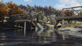
Point Pleasant collapsed bridge over the Ohio River
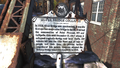
Bridge sign mentioning the Ohio River


References
- ↑ Fallout 76 Vault Dweller's Survival Guide/Atlas of Appalachia p. 294: "ZONE B: NORTHWEST FOREST AND POINT PLEASANT
"This sliver of the Forest follows the winding Ohio River, the western boundary of Appalachia, and is mainly comprised of wooded and mountainous terrain."
(Fallout 76 Vault Dweller's Survival Guide)